Gpredict Software
Installing software Gpredict
Gperedict (picture 1), created by Alexandru Csete, is made for controlling rotating device of the directional antenna 430-440 MHz.
You can download the latest version of software Gpredict from the web-site.

Picture 1. Gpredict
Unzip the program to the root of the C: drive.
Launch gpredict.exe – the main window of the program will open.
Interface of the software Gpredict (picture 2)

Picture 2. Gpredict interface
- You can see on the map the current location of satellite on the orbit, projection of orbits on the Earth’s surface, satellite’s field of visibility above the horizon and location of the receiving station.
- You can see on the radar a current location of the satellite in the sky. Zenith is in the center. Cardinal pIn the window Parameters of orbit are basic parameters of orbit, time of the closest уvent and doppler’s shift.oints are marked with letters: N - north, S – south, W – west, E – east.
- In the window Parameters of orbit are basic parameters of orbit, time of the closest уvent and doppler’s shift.
- You can add satellites and change appearance of the interface n the settings of the program.
- You can update satellite’s orbital parameters in menu and change settings of radio transmitter and rotating system.
Setting location of the ground station
In the first launch the ground station is in Copenhagen, where lives the developer of the software Alexandru Csete.
You should add your exact geographic location for correct work of the software.
Open Edit and choose Preferences (picture 3):
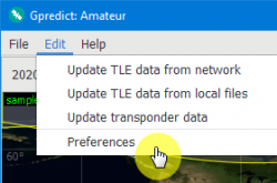
Picture 3. Edit
Click Ground Stations and choose Add new (picture 4):
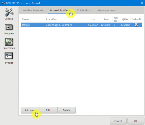
Picture 4. Add new
Fill in the name of the station in the field Name and press the button Select (picture 5):
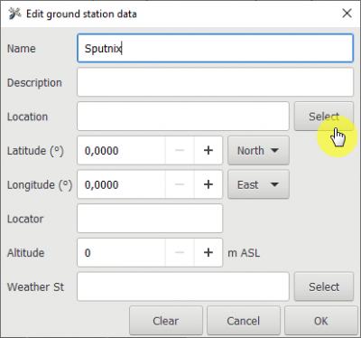
Picture 5. Edit ground station data
Then choose continent Europe, country – Russia and the city, for example, Moscow/ Vnukovo. All parameters of the ground station will be updated from the background information (picture 6):
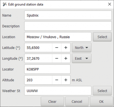
Picture 6. Setting location
- Latitude - 55,65°
- Longitude - 37,267°
- QTH-locator - KO85PPtip
You can read more about the QTH-locator here.
- Altitude - 203 m
- Weather station - UUWW
Press the button ОК to close the window and your ground station will appear in the list (picture 7):
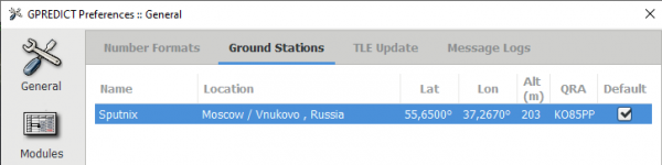
Picture 7. List with ground stations
Updating TLE
The program will ask you update TLE in the first launch.
In Menu choose Update TLE data from network (picture 8):
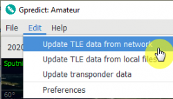
Picture 8. Update TLE data from network
It is recommended to update TLE every day each time you launch the program. For auto-update you should choose parameter Perform automatic update in the background (picture 9):
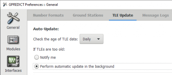
Picture 9. Auto-Update